Monday, December 8, 2014

This is the End

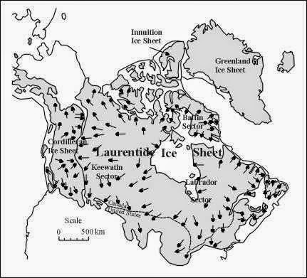
Mt. Katahdin had stood tall for millions of years, slowly being revealed by eons of glaciers crawling over its crust, exposing the grandiose granite monolith to the world. Erratics are strewn across the landscape, along with thousands of kettle lakes, ponds and streams. Everything you lay your eyes on here was either formed by, or heavily influenced by glacial advancement, stagnation, or withdraw. The cirques and col, the striations on the boulders, the craggy exposed granite aréte known as the knifes edge, all are by-prouducts of the mighty Laurentide Ice Sheet that engulfed the continent 90,000-20,000 years ago. As it slowly withdrew, it left massive moraines in its wake, ever heard of Long Island, or Cape Cod? Finally on its way out of the United States, its massive weight and motion peeled away the outer layer of the Mt. Katahdin landscape, leaving what essentially what we see today.


Shown here is a wide angel view of the 5 peaks of Mt. Katahdin, in the foreground is one of the thousands of ponds formed by the glacial withdraw during the last ice age.
http://www.bio.umass.edu/biology/conn.river/iceages.html


Mt. Katahdin 10,000 years from today

I believe that Mt. Katahdin and the surrounding landscape will be mostly unchanged in the next 10,000 years, as on the geographic scale, 10,000 years is nearly unnoticeable. It is likely though that many more tonnes of granite will freeze-thaw and leave even more deposits of jagged granite stones on the peaks of Katahdin. In addition to this, I also believe that 10,000 more years of off-shore winds blowing on the mountain will cause a slight deformation in the area that receives the most wind, as some of the dust, gris, and other small debris will be blown away.

Mt. Katahdin 1,000,000 years from today
Mt. Katahdin 1 million years from now would be an even more impressive sight than it is today, as the next ice age we have may take place about 250,000-400,000 years from now and will have peeled away even more of Katahdins surrounding lowlands. The immense pressure generated by the glaciers mass will rearrange even more till and erratics throughout the area. Mt. Katahdin itself may even look  cleaner, fresher, as the millions of tonnes of small rocks and debris that litter its peaks will be washed away to lower elevations by the glaciers motion.


Mt. Katahdin 100,000,000 years from today
Welcome to my chosen landscape, 100 million years from today, its not a pretty picture, the planet has destabilized drastically, no life has lived here for nearly 1.5 million years now. A massive solar flare blasted over Earth and literally stripped away the entire atmosphere, and since then, the planet has gone haywire. A super volcano located on a "hotspot" deep in the North American tectonic plate erupted 4,200 years ago and hasn't stopped releasing its magma load upon the planet.With the planets core releasing so much pressure through such a small opening, its has slowly started to degrade the outer crust over the entire area. This will lead to unimaginable destruction on a cosmic scale, when the pressure finally becomes too much for the globe to contain, the outer crust will shatter like glass, and the entire planet will explode instantaneously, launching matter into the dark vacuum of space, possibly seeding another planet in our essence and provide the chance for life to start again.


P.S. I love rocks ;) 

Thursday, November 13, 2014

Temperature, Precipitation and Wind

While Mt. Katahdin lies in central Maine its average year round temperature is around a relatively cool 38.6 degrees Fahrenheit. The full range of temperatures that Maine has recorded ranges from a chilling -45 degrees to a steamy 100 degrees. While Maine does experience very cold winter months, it has all four seasons clearly represented. Covered in seemingly never ending forests of deciduous trees and spotted with multiple species of evergreen, Mt. Katahdin's surrounding valleys turn into a kaleidoscope  of oranges, reds, yellows, and greens. 

This is a view from Interstate-95 running north from the city of Bangor. You can see the majority of deciduous trees have already changed colors while the tops of the evergreen trees poke out above the canopy. 


Precipitation around Mt. Katahdin is pretty consistent throughout the year, with lows around 2.58 inches in February and highs at 4.34 inches in October. Snowfall is pretty intense throughout the winter, further aiding in feeding the local stream and ponds from the spring runoff. Spring showers pick up in March and percipatation steadily increase through the summer rains, until the slightly drop in August and September before the winter snows return. 


Often times, hikers on Mt. Katahdin will get to highest peak and be able to look down at the tops of clouds. Pictured here below are some lenticular cloud formations as observed while looking from Hamlin peak. There are seven or eight visible ponds below the clouds, evidence of the water table level surrounding the mountain. These ponds are often created from excessive runoff from precipitation on the mountain before the spring melt. 

Mt. Katahdin's position jutting out of the relatively flat surrounding territory lends itself to exposure of high winds that can occur due to the Northern Trade Winds sweeping through from Canada and the western United States. The problem can quickly be compounded when played in turn with the ever famous North Eastern Winds, this disparity of high and low pressure and warm and cold air can cause quick forming storms to sweep in from the Atlantic, known as Nor'Easters. 

Monday, October 13, 2014

Breaking Down the Mountain

Throughout the last few hundred million years Mt. Katahdin has undergone multiple natural events that have caused varying levels of degradation to the landscape. Glaciers dominated the landscape off and on throughout the Pleistocene Epoch (1.5million-10,000 years ago). This left hundreds of small basin ponds, rivers, streams, all over the area. The weight of the ice also forced rock debris to be strewn far from the place of origin. Some of which were boulders the size of houses, others minuscule pieces of granite known as grus. 


With all the glaciers having fully receded after the last continental ice sheet passed through around 25,000 years ago, Mt. Katahdin has had much of its weathering and erosion take place at the hands of the precipitation,epilithic organisms such as lichen or mosses, and the all mighty gravity. Whether from rushing springs streams from the winters melted snow, or the freeze-thaw that takes place much of the year due to Maine's climate, the end state is the same. Rocks, water, debris, trees, and such will move towards the pull of earths gravity. In the picture below we can see a culmination of many of these factors. Melting snow has created a steady streaming waterfall, the rocks are being broken down from lichens and mosses feeding off of them, freeze-thaw has riddled the granite with cracks and breaks, roots from nearby trees exploit these openings. With time passing, the roots of all the plants eat away at the rocks enough for the water to wash them away and smooth into alluvium which will line the stream beds and river banks. 


A waterfall stream showing water erosion from gravity's downward pull, rock decay, chemical decay from the lichens, and even root pressure from the nearby trees.


Here you can see snow still on the top of the mountain in early June. Snowfall varies from year to year, with melt times also varying due to climate fluctuations. Once melted, this water will carry pieces of colluvium down the mountain. 

http://www.5lakeslodge.com/katahdin-hiking-hunttrail.asp
http://maineanencyclopedia.com/geology/


Thursday, September 11, 2014

"The Greatest Mountain"

The Penobscot Indians must have been justifiably impressed when their ancestors first laid eyes on Mt. Katahdin, so much so in fact, they named it simply "Katahdin", which translates to "The Greatest Mountain".  A five peaked laccolith formed from a granite intrusion in the Early Devonian era, nearly 400 million years ago by molten rock which cooled and hardened about two miles below the surface. Through hundreds of millions of years of orogenesis and then weathering, the huge massif finally broke through the cold top layers of New England soil. This massive weathering campaign was aided by glacial deterioration, as evidenced by the abundance of clues left to us from the icy giants, from the ponds, to the aretes and cirques.


Here, we can see a great view of Mt. Katahdin and the surrounding area. Take note of the geographic features that formed secondary to the mountain itself, i.e. the basins and ponds surrounding Katahdin.


Mt. Katahdin sits about halfway between the east and west borders of the North American Tectonic Plate(the eastern half anyways), which means that while earthquakes do happen, more often than thought most of them go unnoticed or are very mild (the strongest quake reported in Maine occurred in 1904 and had a magnitude of 5.0). While the plate shifts slowly at about 1cm a year, small releases in the built up pressure result in the quakes.

A view of the North American Plate (in brown) in relationship to the rest of the worlds tectonic plates.

Over all of Mt. Katahdin and its five peaks you will notice an abundance of multi-sized granite boulders which appear to have been split by Zeus himself. However, due to the thankless nature of the task, we can draw the conclusion that these were victims of freeze-thaw. A natural phenomenon in which water finds its ways into tiny fractures or void spaces inside the rock, then freezes when temperature plummet, causing the water to expand, and therefore break or split it open. This process happening repeatedly over millions of years has for split some rocks maybe thousands of times over, resulting in miles of jagged granite stones, much like seen below. 


Here is a great example of "freeze-thaw", notice how some edges are very geometric or angular, this can lead to serious injuries to climbers and local fauna alike.


Here you can see one side of the aretes known as "The Knifes Edge", also in the foreground some "freeze-thawed" rocks are prominent. 

This diagram shows a clear model for how the phenomenon known as "freeze-thaw" occurs.


Thursday, August 28, 2014

Katahdin

Greetings,

My name is Miguel Sanchez, but you may call me Mike. I am 25 years old, I enjoy spending my free time hunting and watching my favorite TV shows. (Stargate SG-1/Atlantis/Universe; Cosmos; GoT; The Strain) I was a Staff Sergeant in the US Army, and am a veteran of the Iraq and Afghanistan wars. I lived in Germany for three years, and enjoy traveling and seeing European countries and cultures first hand.

For my landscape I chose Mount Katahdin, the largest mountain in Maine, and the northern terminus of the appalachian scenic trail. A popular summer hiking destination for its breathtaking views, it stands 5,270ft (NAVD88) tall, and has multiple peaks. I choose this location because I have a sentimental attachment to it, I personally traversed the summit as a child, spent summers at its foot with my grandparents. I wanted to learn more about it, how it has been shaped and molded by the millennia, as well as its uncertain future.

The extremely dangerous and ever popular "Knife Edge" runs between 
Pamola and Baxter peaks, and has claimed 19 lives since 1963.


Location of Mt. Katahdin in relationship to the state of Maine, and surrounding territories.

Coordinates: 45.9043556° N / 68.921275° W